The information on this page is from my own personal research on the Maromas area of Middletown, Connecticut. This information was just sitting in a big binder, and I thought: "Why not share it on my website! It's doing not good sitting in a binder!" This way the reader may get some idea of what the area used to look like before C.A.N.E.L and Pratt & Whitney came through.
All the images of the 1934 aerial maps seen here are just select portions of larger maps. I actually screen-clipped portions to focus on certain areas. I’ve added notes directly onto most of the aerial images. Enjoy!
In the image above, the road that runs along the front the cemetery is River Road, which portion is now defunct. In 1956 this portion of River Road was covered over and a new road was built, which is currently called Aircraft Road. The area where this portion of River Road used to be is now the grassy median that runs along the front of Maromas Cemetery.
Left:
is a 1955/1956 photograph of the construction of what is now called Aircraft Road. Photo source: Rich Agostinucci.
Above: another view of River Road (now defunct and replaced with Aircraft Road). Notice the little black "speck" on the road, which is a car! Also shown is another view of Maromas Cemetery, followed by a large farmstead with a home and several buildings, one of which is most-likely a barn. North of that is the "New Schoolhouse." Behind the schoolhouse are some homes or farm buildings.
Directly across the street from the “New Schoolhouse” (built 1871) was the “Old Schoolhouse,” which during the time of the 1934 aerial, no longer stood.
Left: a 1954 photo of the “New Schoolhouse,” with River Road (now defunct) in the foreground.
Above: traveling north along River Road, past Maromas Cemetery and the "New Schoolhouse," we see more homes at the top, left of the image, along with a patch-work of fields in the upper right. I don't know the name of the road that comes off River Road on the right. In the 1937 booklet, "Sketch of Maromas," by local historian, Jessie Alsop, the road was un-named at the time. Sketch of Maromas included a little hand-drawn map of the area as it was in 1937.
This portion of River Road is now defunct. No surprise there. Even the un-named road is gone too. The land is now occupied by Pratt & Whitney aerospace manufacturer.
Above is a 1950's photograph of the
James Smith homestead which was located along the now defunct portion of River Road
in the heart of the village of Maromas. According to the 1937 booklet, "The Sketch of Maromas," this is the home that
Robert I. Young superintended the raising and enclosing of. Robert also personally finished the interior of the second story. Robert I. Young was the uncle of
Private Daniel H. Otis (Daniel’s mother,
Elizabeth, and Robert were siblings).
Also, notice the ugly crane out front just waiting to demolish this home.
The heart of the village of Maromas was razed by C.A.N.E.L (Connecticut Advanced Nuclear Engineering Laboratory) in 1956. As previously stated, the area is now occupied by Pratt & Whitney.
Photo source of the Smith Homestead: Rich Agostinucci.
Above: Maromas Road is still active and currently comes off of Aircraft Road. The lower portion of River Road is still active and also comes off of Aircraft Road. However, the top portion of River road, the part that runs northeasterly, is currently defunct and literally no longer there. Aircraft road has been built in its place (see the photo at the top of this page of Aircraft Road being built).
A partial view of Maromas Cemetery can be seen in the top, right corner of the above aerial photo.
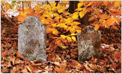
The 1885 book, “History of Middlesex County, Conn.,” (Published by J.B. Beers & Co.) calls Prior Cemetery, “The Old Cemetery in Maromas,” and says that “this yard contains but a few graves; and it was used only a short time for burial purposes. The oldest date recorded in the cemetery is that of 1708; and the latest internment designated by a tomb-stone was made in 1754. The time of the layout is unknown.”
Currently, Prior Cemetery is a forlorn little place out in the middle of the woods near the Connecticut River and the old Maromas depot. Gaining direct access to it is impossible without the assistance of Pratt & Whitney to let one traverse their land as a shortcut. Otherwise, a good long walk along the old train tracks is the only option for access.
Left:
Get your hiking boots on! Take the imaginary "train" to Prior Cemetery. Photo: Reg Bacon.
Two forgotten Prior graves at Prior Cemetery: the "little cemetery in the woods."
Photo: Reg Bacon.
Photos and maps of old Maromas are scarce. Perhaps it was because of the relative isolation of the area. However, I have been told by a Maromas native (whose great-grandparents had a farmstead on the now defunct portion of River Road in Maromas), that when C.A.N.E.L came through in the 1950’s they intentionally destroyed many of the old maps and photographs of the area. Crooked ‘ol C.A.N.E.L. What were they trying to hide? C.A.N.E.L basically obliterated and buried this community.


